Los Altos, we have a final map.
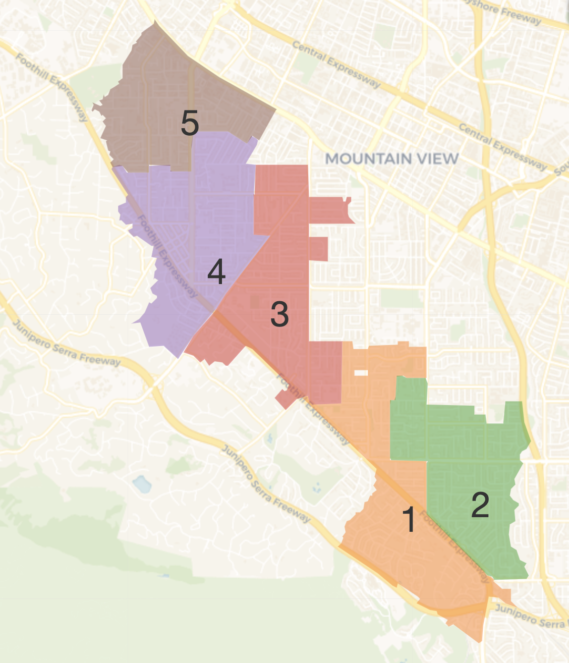
The city council last week approved F2a as the selected map for dividing the city into five separate voting districts.
Council members, struggling through numerous iterations of maps and clashing perspectives from the public (and among themselves), found a three-vote majority to approve a map divided along main thoroughfares like Foothill Expressway and El Monte Avenue, and consolidating shared-interest neighborhoods – all the while meeting the requirements of contiguous, similarly-sized districts with populations each in the 6,000-plus range.
Mayor Jonathan Weinberg, and council members Sally Meadows and Lynette Lee Eng voted in favor of the final map. Councilmember Neysa Fligor and Vice Mayor Pete Dailey voted against it. The council had until Oct. 31 to approve a map.
The council approved a first reading of an ordinance relative to the map decision, with a second reading due at the Nov. 12 council meeting. The ordinance would become effective 30 days after that.
As part of the decision, the council approved a numbering sequence of the districts to go from south to north with the Highlands area numbered district 1, Grant Park, area 2, the Covington and Almond neighborhoods numbered district 3, the Los Altos High School and downtown areas labeled area 4 and northmost Los Altos, including Santa Rita and Egan Junior High schools, numbered 5. Residents in areas 2 and 4 would vote first in 2026, with areas 1, 3 and 5 voting in 2028.
Finally, council approved a condition that candidate must live in a district at least 30 days to be able to run for council.
The city undertook the arduous exercise in the first place because of a legal challenge that the city’s current at-large election format is in violation of the state’s Voting Rights Act. The change to by-district voting cures the legal challenge.
“It was tough because everyone has a different vision for what a map of Los Altos would look like,” said Weinberg. “I’m really proud of the way my colleagues handled this.”
Throughout the process, there was no uniform agreement by council or residents on any of the final 12 draft maps, or maps drawn by members of the public. Weinberg said, given time constrictions, the choice would be “the best of the worst.”
Fligor lobbied for two map alternatives, including map C, which had separation of the Highlands neighborhood from north of Foothill Expressway. She saw the council-selected District 4 of map F2a mixing the Highlands with neighborhoods north of Foothill. Lee Eng had lobbied to keep the neighboring Grant Park neighborhood together as one district. Highlands eventually became District 1, with Grant Park, District 2.
“I don’t think the case was made to justify districts 4 and 5 (which were renumbered as 1 and 2), meeting the communities of interest,” Fligor said. “I think we ended up with a map where you’re just putting neighborhoods together for different reasons, but you’re not saying, these neighborhoods have traffic in common, or they have the downtown in common, or they have two hotels.”
Still, Fligor respected the decision.
“We all are moving forward together,” she said. “In the end, we did (approve) an ordinance that included not just the map, but what we’re going to do with regards to the residency requirement, what we’re going to do to which districts go first. And those were unanimous decisions.”
The impact of the Oct. 22 council decision is yet to unfold, but some residents and council member fear district-based voters will encourage council members to advocate only for their district, not for the city at large.
“The current council composition, if we were district elected officials, I think we would rise above that and still do everything in the context of the city,” Fligor said, “and I think it’s because we all came from an at-large system. But we have to fast forward to folks who are going to get elected based on their district residents. It’s going to be a completely different approach, and it’s going to take time for the community to realize how bad it is.”
The switch to district-based voting was panned by both council members and residents. The allegation was that Los Altos was engaging in racially polarized voting, shunning Asian residents, but the city has no concentrated groups of residents from different countries.
“We didn’t think Los Altos fit the bill, based on the (state’s voting rights act),” Fligor said. “We didn’t have a choice, so we moved forward.”
To view map F2a and for more information about district elections, visit losaltosca.gov.